
Friday, 4 Oct 2019: Around Glenorchy

I was excited for this day, and it did not disappoint.

We woke up to a beautiful, crisp spring morning in Glenorchy. After a quick breakfast, we stopped by the general store for some snacks and picnic lunch and then hit the road.

Spring lambs in the early morning light along the way.

As we approached our destination, the scenery got more wild, and the road got more rough.

One of New Zealand's famed Great Walks, The Routeburn Track was our destination. Our goal was to complete a 3/4 day out and back along the spectacular trail. We accomplished that, hiking ~13.5 km (~8.5 miles) that day.

Looking up the Routeburn: the first part of the trail from this direction follows the Route Burn river up the valley, up into the snow-covered peaks.

And looking back down the Routeburn: The snow-covered mountains in the distance lie on the other side of the large and wild Dart and Rees Rivers.

The surrounding scenery is spectacular, though these come only at open flats or glimpses through the dense and seemingly primordial forest.


There are several creek and river crossings, but good, sturdy bridges have been erected for those tackling the trail.

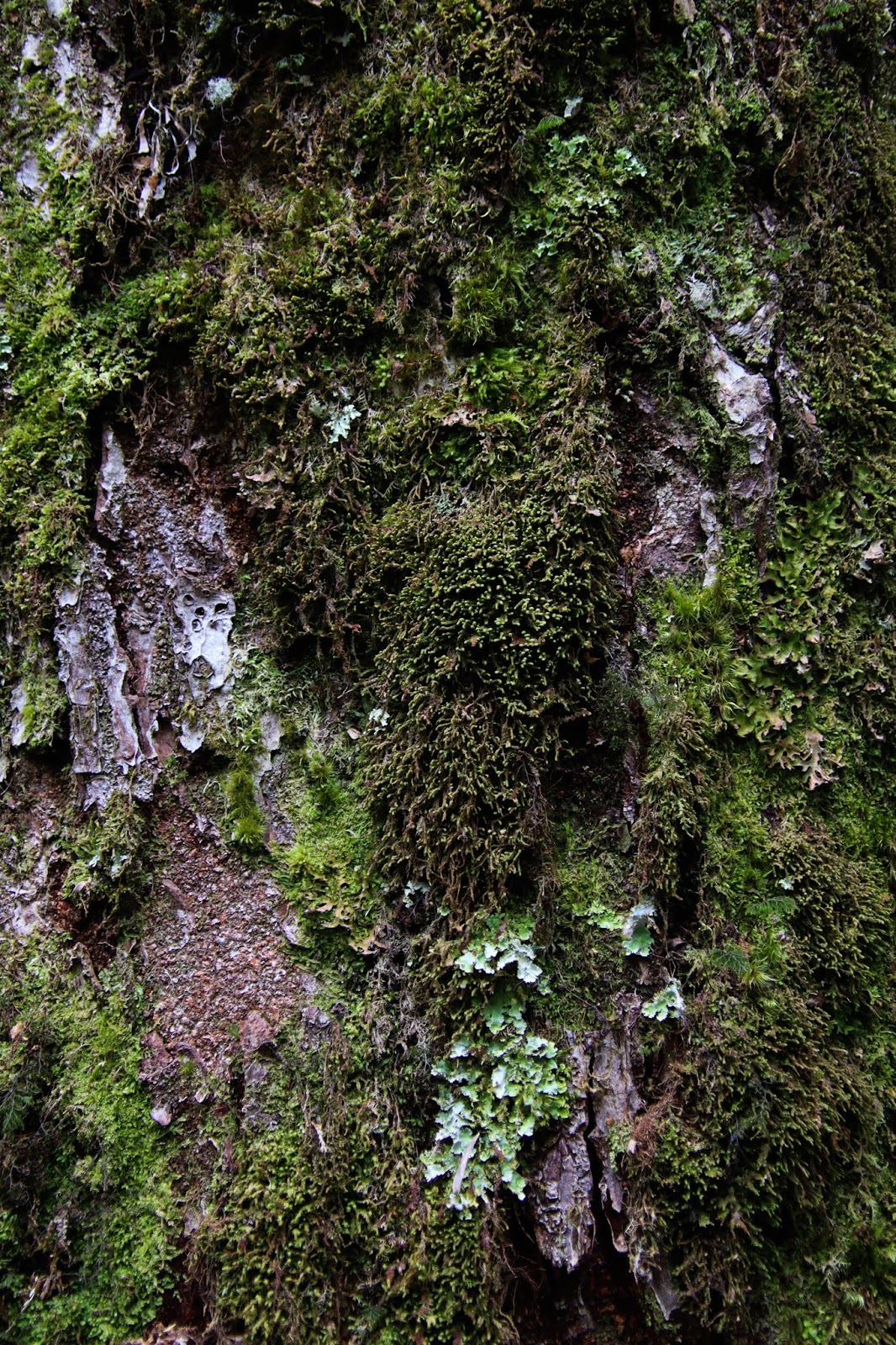
Everything is covered with moss and lichen... it's no wonder either, the climate of the place felt very much like what I knew from the Northern Pacific West Coast of Washington state and British Columbia: cool and wet. With conditions like that, the mild temperatures and abundance of water allows life to cling to just about everything. It's wonderful.

I think this is a big chunk of New Zealand greenstone, pounamu. The mountains around this area are famous for their abundance of pounamu, which is a prized treasure of Māori people. The stone is hard and very durable and can be shaped into tools, weapons, and ornaments.

The water in the river alongside the trail is spectacularly clear and quite blue. It contrasts so nicely against the chalky light rocks.


The Routeburn Flats, looking down the valley.

The Routeburn Flats, looking up the valley.

The Routeburn Falls visible in the distance. There are huts at the Flats and Falls for through-hikers doing the full trail

Yellow-crowned parakeet; Aotearoa really is a birdwatcher's paradise. It will be even more of a paradise if introduced mammal "pests" are ever effectively brought under control enough to allow the remaining endemic bird populations to rebound.

On the hike out, we were treated to some lovely sunshine.

These are some serious gradients here; that summit rises almost a vertical mile above the trail.

The pictures don't convey it, but the trees in this shot give some sense of scale, that is a very high waterfall. It must be impressive and beautiful up close.

Heading back out. I vow that on my next trip to Aotearoa, I'll definitely be doing some overnight backpacking, or "tramping" as they call it there down under. I don't know if I'll be fortunate enough to nab a permit for one of the most popular trails, but there are trails all over New Zealand, and this trip gave me a wonderful list of not-so-well-known, but just as beautiful trails to explore on my next trip.

Back on the road to Glenorchy

The Dart and Rees River valleys are huge, sweeping, flat basins with high mountains on both sides.

The scenery around Glenorchy is truly spectacular.

That afternoon, there was a very, very strong wind coming down from the mountains along the Dart River, bringing all that dust from the rocky river track with it.

Back in town, there are plenty of nods to Glenorchy's Scottish heritage

Glenorchy also boasts the tiniest and most hilarious library I've ever seen

Unfortunately, we also encountered busload after busload of mostly Chinese tourists coming up from Queenstown just to take the same, stupid instagram pics at this red boathouse along the lake. It's infuriating to see the tourist-locusts swarming over such a naturally beautiful setting. I hope that New Zealand does something to reign in and control the damage and destruction that mass tourism brings with it.

Another shot of that dust blowing down the river valleys. In this shot, the Dart River is on the left and the Rees River on the right of that central, dark, forested peak (Mt. Alfred).

Easily tied for the best place we stayed the entire trip: Camp Glenorchy Eco Retreat

Yes, that is the backdrop behind Camp Glenorchy

As the name would imply, Camp Glenorchy is an eco lodge, and the whole place is off the grid, low carbon footprint, and environmentally friendly. It boasts: fully powered by solar panels; all lighting is low-energy; showers and taps run from stored rainwater; toilets are waterless and composting; blackwater is treated before being returned to ground; and all building and decorative materials are sustainably harvested, recycled, or repurposed. Plus the place just has the warmest and most inviting feel to it... we could have easily spent a week or more relaxing there and enjoying treks around the area... maybe next trip we will do exactly that!

Everything around the lodge was decorated by local artists and all materials are recycled, rescued (a polite way of saying scavenged), or repurposed. It's cozy and inviting... we loved it.

Next door to the lodge is Mrs. Woolly's General Store, which offers customers some delicious food and drinks plus some locally produced goods and souvenirs.
Saturday, 5 Oct 2019: Along Lake Wakatipu and onward to Te Anau

We awoke to a beautiful morning in Glenorchy. This was largely a driving day, with our itinerary taking us from Glenorchy to Te Anau, so we had plenty of time along the way to enjoy the scenery on this perfect day in God's own country. Before we left town, we stopped by the boathouse again to try and beat the busloads of tourists. There were already others there that had driven rental cars in from Queenstown, but we still got some relative peace and uninterrupted views.

This is a frequently photographed, bizarre line of trees planted in the lake. I liked the way the line of trees mirrored the ebb and flow of the lines of the mountains in the background.

The mountains around Glenorchy are truly spectacular

I love this picture... especially with the way the light and shadow played over the craggy glory of what I'm pretty sure is Mt. Larkins

Across the lake offers comparable splendor.

Looking down Lake Wakatipu from near its "head" at Glenorchy. Also visible here are the head of the lake's two big islands: Pigeon Island and Pig Island. Funny enough, Pigeon is the bigger of the two.

Partway along the drive back to Queenstown, looking back up towards Glenorchy and the Wizard's Vale.

Looking across the lake at the Caples (rightmost) and Greenstone (leftmost) river valleys: The tramping tracks along these two rivers are goals for my next journey to Aotearoa.

These views are almost unbelievably beautiful, as if you'd transcended to some higher and much more serene state of existence, and the deep, cold lake was what seemed like an impossibly bright shade of gemstone blue.

A quick stop at the perfectly named for the day Sunshine Bay to take in more views over the water near Queenstown

The Remarkables across from the "knees" of Lake Wakatipu at Sunshine Bay


There were Clouds pouring over The Remarkables by the time we got around the "knees" of the lake and alongside the mighty range

A short detour for some nostalgia along the beautiful Kawarau River

I've only ever bungy jumped once in my life, and it was here. AJ Hackett Bungy has set up shop at multiple locations around Queenstown, and their Kawarau Bridge site was the original. Their bus, with their "Live More, Fear Less" logo emblazoned on the side, is seen crossing the other, newer Kawarau Bridge in this shot. Daring tourists don't take the dive off that new bridge but the old one that I was standing on to take the shot.

Looking down from the Old Kawarau Bridge at the retrieval team below.

Geronimo! This guy was flipping most of the first half of the way down. Here you see a bungy jumper taking the leap toward the beautiful turquoise water below. The Old Kawarau Bridge runs along the upper left of the shot, with that retrieval team in their big yellow raft below.

At this point, the bungy line is just about to start to catch and slow the jumper down.

The catch and rebound is so gentle, surprisingly so, though it makes perfect sense for anyone familiar with the spring equation from high school physics. AJ Hackett understand these physics well... if desired, jumpers can ask to be submerged from head up (remember, you're hanging upside down) to about your knees or anywhere in between that. They control this given your weight and careful selection of the spring constant for the bungy cord they assign to you. It's brilliant, and they nailed it for me... I got submerged from head to hips, just as I had requested!

And now the retrieval team's function might make more sense. After a jumper is done with their jump, they are lowered from above to the water below. The retrieval team plucks each jumper from the void and delivers them safely to the staircase along the shore.

Back on the road and stuck behind one of the ever-present, and ever-slow-going, rental camper vans that so many tourists and travelers use to get around New Zealand. I have nothing against these really; they are infinitely better than tour buses.

Looking back on The Remarkables

And back toward Queenstown

The lower half of Lake Wakatipu, below the "knees"

And looking to the "foot" of the lake and the small town of Kingston

After a few more hours of driving through much less scenic and quite dry northern-central part of Southland, we reached the small and pleasant town of Te Anau, which serves as the gateway to the epic Fiordland National Park. This shot is looking across Lake Te Anau toward the famous Kepler Track.

Kowhai in bloom in Te Anau
Sunday, 6 Oct 2019: Fiordland

Best day ever? Close for sure... a perfect day in Fiordland National Park.
I was going to try and keep this post to ≤ 10 pictures, but yeah, that's not happening. These are too good not to put out there and share. So, lots of pictures that speak for themselves and very little text to go with it. Enjoy nature's show folks!

Beautiful, but frosty morning driving through the Eglinton Valley, which is somewhat of a gateway for the only road that enters Fiordland National Park.

This shot was from the drive out in the afternoon, when the sun was lighting up the mountains on the opposite side of the valley

The aptly named Mirror Lakes. My shots turned out a bit better from this trip compared to the last time I was here in 2006.


This shot is near identical to one I took 14 years ago.. this one though is graced by a diving duck.


I have no idea what kind of bird this is, but the very little guy seemed to stop to appreciated and enjoy the view into the spectacular landscape bathed in morning sun just the same as I did.

The driving through the park is some of the most spectacular I've ever experienced.


An industrious woman and her husband had set up a little coffee shop out of their van at this spectacular spot to pull over and take in the view. Much of the drive along the higher elevations was clearly marked to prohibit pulling over or stopping of any sort. The justification was given as avalanche threat, and it is clearly understandable that such a threat is legitimate when you look to the tops of those steep cliffs and see so much white hanging up there above you. Despite what seems to me as common sense, I was pleasantly surprised that we didn't see any cars stopping where they shouldn't be; well done people.

The view after going through the Homer Tunnel, which cuts the trail through a wall of rock at the highest-point along the road to Milford Sound.


There is no real sense of scale here, but this mountain shot up out of the landscape and dominated close to 180 degrees of horizon plus >45 degrees of elevation up off of it. That is 1.6 vertical kilometers (almost exactly 1 vertical mile) rising up beside the road in less than 1.5 km of horizontal distance.


The Maori name for Milford Sound is Piopiotahi. Despite the English name, Piopiotahi is actually a fiord, as are all of the coastal inlets along Fiordland National Park's epic shores. Maori legend has a couple legends explaining the formation of Piopiotahi. One involves a wager with the Goddess of Death and her nasty and spiteful trick of adding the blood-thirsty and near-invisible sand flies to such an otherwise spectacular wonderland. Another involves an ancient god carving the landscape out of the bare rock with a giant adze.


We were lucky with bird sightings this day

A weka with its chick; look at how big those legs are compared to the bird itself.


I, like most people at Milford Sound, took a ton of pictures of the iconic Mitre Peak, originally named Rahotu by the Maori. This spectacular summit rises nearly 1.7 km (over a mile) up out of the sea. On a good clear morning like we were graced with, it offers a spectacularly dramatic feature to be mirrored in the deep, dark waters of the fiord.
We ended up convincing ourselves to splurge for a 2.5-hour cruise around the fiord... it was an excellent decision.


Those walls plummet into the sea just as sharply as they rise up above it, and the ship's captain proved this to us again and again by running the course right along the near-vertical shoreline.

The boats can pull right up underneath several of the falls; at this one, the crew set out several trays of empty glasses on the prow. The waterfall filled them up, and they were handed out to each of the passengers for a refreshing drink of pure, clean water, fresh off the mountain.


Looking down the fiord towards the West and the Tasman Sea

At the end of Milford Sound (the Fiord of Piopiotahi), looking out on the Tasman Sea. The next piece of land one would hit continuing to sail west from here would be Tasmania.

Looking up the fiord into Fiordland


Mitre Peak, side-on; it looks a lot different from every angle


Mitre Peak is really the dramatic highpoint along a very, very extended ridge line. That is the nature of Fiordland, long deep and narrow valleys and fiords between drastic, steep-sided ridges and summits.


On our boat tour, we learned a very interesting thing about the primordial forests of Fiordland. These trees are collectively known as a catastrophic rain forest. Any trees growth is ultimately limited by the steep gradients and the depth to which it can burrow its roots. Once too big for the depth of the roots and steepness of where it has planted, and most often under the ever-present forces of water erosion, a tree will fall. Along such steep mountainsides, a falling giant ends up taking everything below with it, resulting in those distinct scars along the mountainsides. The one in this picture is truly epic in its scale, with possibly just one tree from the top responsible for wiping out more than a fifth of growth and life along that flank of the mountain.

This same bay offered us some tantalizing glimpses of the pristine glaciers that rule the realms of Fiordland's highest places

The ever-present snow-capped mountains and gushing waterfalls of Fiordland on a truly picture-perfect day.


This waterfall powers the National Park Visitor's Center and Accommodations at Milford Sound


Of course, it wouldn't be a drive in New Zealand without a single-lane bridge

Finally, a kea! We saw this guy at the car park for The Chasm. These birds are very intelligent, and you can tell that just from watching them. This guy came to check out the human action in the parking lot and was particularly interested in a young family whose kids were enjoying some snacks. He showed no fear whatsoever getting right up to mom and kids, but they were good and didn't give the little beggar anything. We walked away, head hanging lower and without the perk he had exuded on approach.


Don't be so sad buddy; it is illegal for people to feed you!

And the rain forest, clinging to the sides of these epic peaks


Waterfalls on approach to the Homer Tunnel


This kea came to check out the cars stopped to wait for our turn through the tunnel... another beggar, but this one gave us a little show. These birds are known to be very good at problem solving and also can be quite destructive to campsites and cars. Apparently, they will take out their frustrations for not being fed human treats.


And the view back out on the other side of the Homer Tunnel


We were riding high after such a spectacular day. We knew how very lucky we were to get such a beautiful, blue-sky day in one of Earth's most spectacular (and wettest!) places! That evening, back in Te Anau, we took in sunset over the mountains across Lake Te Anau and then basked in our good fortune as we enjoyed a delicious meal at the wonderfully charming Redcliff Cafe, just across the street from Lions Park. This will definitely go up on the list as one of my favorite days ever.
Monday, 7 Oct 2019: Te Anau to Tekapo

From the trailhead for the famous Kepler Track: looking across Lake Te Anau to the town of the same name on a fine South Island morning.

Turning to the left from the first picture and looking north along the full length of Lake Te Anau

Turning left once more and looking at more of the mountains of Fiordland National Park and the Kepler Track

The beautifully calm, reflective, clear, and green Waiau River


Back in Te Anau, we enjoyed a delicious breakfast at the Habit Foods food-truck, which served up tasty and spot-on fluffy-chewy bao bun options.

On the road towards Laka Wakatipu

And back again at the impossibly blue Lake Wakatipu, looking north toward Queenstown

Alongside The Remarkables in all their rugged glory

On the highway between Otago and Canterbury, we entered a dry hillscape that was very reminiscent of many of the Rohan scenes from Lord of the Rings

Passing through Twizel and the high, sweeping plains, we saw plenty of signs informing us that we were in Dark Sky Reserve territory. The Dark Sky Project is an organized effort to maintain near-pristine night skies for stargazing in the Dark Sky Reserve around the Lake Pukaki and Lake Twizel areas, a huge area of broad, open, high-altitude plains with famously dark skies.

Coming up on Lake Pukaki, we realized that bizarre chain of clouds was pouring off of Aoraki, New Zealand's highest peak!

I really, really couldn't believe our luck... given two days on either side (along the West Coast a few days earlier and now from the east side at Lake Pukaki) of the spectacular mountain and its partner, Horokoau, we managed to have clear, uninterrupted views of both mountains. Given their infamy for remaining shrouded in thick clouds, we were gifted with such serendipity.

Compared to the view from the West Coast, where one is closer to the mountains, I think this view is actually better, since the lake offers a chance to appreciate just how enormous Aoraki really is. Though nowhere near one of the highest, Aoraki is one of the world's 50 most prominent mountain peaks (39th on the list).

Lake Pukaki also treated us to this spectacular mirror show.

The chain of clouds pouring off of Aoraki is classic weather: as warm, humid air from the Tasman Sea blows over the South Island, it is forced up and over the Southern Alps. When forced up and over, the air cools and water vapor condenses, forming clouds. On this relatively dry day, Aoraki was one of the few peaks that was actually spitting off a chain of clouds, due to its height and frigid temperatures above its lofty summit.

And at our destination for the night, Lake Tekapo and its eponymous town. Tekapo is a tourist trap by all definitions of the word. The restaurants there are terrible, and there doesn't seem to be anything at all resembling local culture or life. The town seems to exist solely for tourists coming to see that stone church and stargaze in the famous Dark Sky Reserve. We had cloudy skies and rain that night.. oh well... the views during the day more than made up for it!

This scene might look familiar to fans of the Lord of the Rings movies. That church was inundated with countless tourists snapping pictures, surely to pointlessly show off on their instagram feeds. The scene from across the water was beautiful in the setting sun.
Tuesday, 8 Oct 2019: Akaroa

Akaroa: When I came to this stunning and tranquil peninsular harbor on a day trip from Christchurch on my second visit to New Zealand (returning from Antarctica) in January 2006, I vowed to return to Akaroa one day, preferably with my partner since the place is so damned romantic. With this honeymoon trip alongside my new wife, I was able to deliver on that promise to myself made so many years before! I was so happy to see this perfect vista greeting me again 14-years later.


Akaroa Harbor is one of several harbors and bays scattered around the Banks Peninsula, which formed during the Miocene Era (~10M yrs ago) when a volcano burst up from the seabed. When you sit in Akaroa Harbor and look at the high hills all around it, it is not difficult to imagine how you're actually sitting in the remnants of an ancient caldera! The current state of the peninsula is about as polar opposite from its fiery inferno past as it can get though...

Now, Akaroa Harbor is idyllic and tranquil, with serene turquoise waters surrounded by bright green, gentle hills under soft blue skies.


Akaroa Town is a sleepy and charming little place.

The town was first founded by French settlers, and the pride in French heritage is felt all over town, from the French road signs and names..

To the French tricolor manifested in various ways all over town.


The beach may be rocky...

But it also offers some great views for sunset. We enjoyed some drinks and food around sunset at the HarBar, which is right on the sand. Being a popular destination for those with demanding tastes, there are some excellent food options around town. We ate well there!

Wednesday, 9 Oct 2019: Picton to Wellington

Kaikoura marked the end of our travels on the epic South Island; we returned to Wellington and the North Island on this day. The drive from Kaikoura to Picton, where we would catch the Interislander ferry back to Wellington, took us through the scenic Marlborough wine region.

Back in Picton on another beautiful day to cross the Cook Straight. We enjoyed a pleasant lunch at a little cafe by the harbor and this WWI Memorial.

Goodbye to Picton!

We were so lucky to get another picture perfect day for the crossing. We enjoyed a very peaceful day on the ferry. We setup shop in the sunroom/observatory deck and just lounged there, napping and reading in the sunshine and enjoying the views of the surrounding sea- and landscapes slowly passing by.

The spectacular and complex coast of the Queen Charlotte Sound and the Tory Channel.

From the South Island looking to the North Island in the distance...

And vice versa: North (nearby) to South (distant)

Hello again, Wellington!

That evening, we enjoyed a delicious sushi dinner and then went on a little cocktail crawl. The picture above was taken at the Hanging Ditch, which had this super innovative way of storing the bottles above the bar using bungee cords! We also enjoyed some fantastic, tasty, and innovative tipples at The Library (which was very crowded!) and Crumpet, which was also phenomenal and adjacent to the beautiful Opera House. Great evening in Wellington all around and a very enjoyable way to end such a lovely and loungy day.